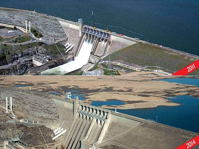
The severity of California’s current drought has been realised by the release of two Nasa pictures of Folsom Lake and the desolation it has suffered in just two and a half years.
The reservoir, located northeast of Sacremento, California, can be seen almost full on July 20, 2011, measuring a capacity of 97 per cent. But in a shot taken just last month, the lake had a capacity of just 17 per cent.
The devastating images have added to the need for the west coast to better manage its water resources, with the record drought forcing a state of emergency and Nasa now working to help the crisis.
According to the Christian Science Monitor, ten rural communities have fewer than 60 days’ water supply. Water deliveries to 750,000 acres of farmland and 25 million people have been halted, with the carryover water from last year that is in reservoirs to be channelled to the farmers and several towns that get their water from the State Water Project.
Furthermore homeowners are drilling thousands of wells to pump water from aquifers that are historically depleted.
Last week Gov. Jerry Brown unveiled a proposed $687.4 million drought-relief package to free up water supplies and aid Californians facing financial ruin because of the prolonged dry spell.
The proposal would provide millions of dollars to clean up drinking water, improve conservation and make irrigation systems more efficient. It would also increase penalties for those who illegally divert water and provide emergency food and housing. But the package plan came after farmers faced the driest year in more than a century.
Farmers in California’s Central Valley, the world’s most productive agricultural region, will get none of the water they requested this year from a federally controlled system because of the drought.
The US Interior Department’s Bureau of Reclamation said last week it won’t be able to deliver any of the more than 2.4 million acre-feet of water sought by farmers, according to AG Web.
A state-controlled system last month said it, too, wouldn’t be able to deliver any of the 4 million acre-feet of water sought by local agencies. The result will hundreds of thousands of acres of farmland die, boosting food prices across the US and leaving farm workers jobless.
The California Department of Water Resources has now partnered with Nasa to use the space agency’s satellite data and other airborne technology to better measure the snowpack, groundwater levels and predict storms. ‘It sounds like a cliche, but if they could put a man on the moon, why can’t we get better seasonal forecasting?’ Jeanine Jones of the state’s Department of Water Resources said in an interview following the Sacramento announcement of the partnership. Now they will.
Nasa scientists said they are also embarking on projects that use satellite images to help more accurately measure the number of fields farmers have chosen not to plant and where land is sinking because of excessive ground-water pumping.
Gov. Jerry Brown directed state officials to form such partnerships as part of his drought emergency declaration.
California’s relationship with Nasa began shortly after the dry year of 2009, when officials sought answers to problems exacerbated by the lack of rain and snow, such as the sinking land.
This year’s drought has made that research all more important, Jones said, adding that the preliminary findings proved that there’s plenty more to learn.
Nasa geologist Tom Farr said that bringing together all types of research and modern technology like pieces of a puzzle may help those in charge of managing the state’s water supply avoid deficit water years like this. ‘We’re on the verge of being able to put all these measurements together and start looking at the concept of closing the water budget of California,’ he said.
Lawrence Friedl, director of Nasa’s Applied Sciences Program, said that 13 of the agency’s satellites are focused on water. Three more water research projects are scheduled by Nasa, including a satellite to be launched Feb. 27 with the Japan Aerospace Exploration Agency. Projects Nasa is advancing include measuring so-called “atmospheric rivers” to better predict global storm systems farther in advance so rain can be captured in California reservoirs.
Satellite images that show the amount of land farmers have chosen not to plant in a drought will arm officials in Sacramento with information about where to open food banks for farm workers.
Satellites technology will help officials identify levees that are prone to break with high volumes of water, scientists said.
As Ed Osan, senior policy analyst with the Natural Resources Defense Council (NRDC), explains, metropolitan cities like Los Angeles, San Francisco and San Diego have been largely unnafectted because they started developing ways to catch and retain water following the drought from 1987 to 1992. In 2003, California signed onto a new water-sharing agreement that included ‘the largest transfer of water from agricultural use to urban use in US history,’ according to the Association of California Water Agencies.
‘California cities really got their act together and began coming up with formal drought plans two decades ago,’ says Timothy Quinn, ACWA executive director. ‘Now, they’re reaping the benefits of that planning.’–Daily Mail
CONNECT WITH US
California drought laid bare
Caption: California drought laid bare
ePaper
ePaper - Nawaiwaqt

NIPCO House, 4 - Shaharah e Fatima Jinnah,
Lahore, Pakistan
Tel: +92 42 36367580 | Fax : +92 42 36367005
Nawaiwaqt Group | Copyright © 2024
